2,407 results
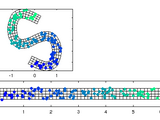
Visualize and manipulate parallel coordinate plots with this GUI. UNIVERSITY OF BRISTOL

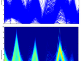
The interactive Parallel Coordinates allows you to explore complex data sets
The Interactive Parallel Coordinates plot allows you to explore interactively a complex data set. The Interactive Parallel Coordinates plot is for instance useful to discuss different trade-offs of a

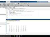
Parallel Coordinates Plot with MATLAB
design space diversity of a medium-frequency transformer is considered:run_parse.m - Extract and parse the datasetrun_plot.m - Make the parallel coordinate plot CompatibilityThe tool is tested with the
Generates the outer and inner parallel curves in rectangular coordinates.
. Use option flag1=0 to keep the parallels on the side sides (disregarding concavity). The Input the x, y coordinate pairs and distance between the curve and the parallels and the option to make a plot

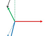
hg = plotframe( rotationMatrix, translationVector, basisVectorLengths, Name=Value )
plotframe: Plot a 3-D Cartesian coordinate systemSyntaxplotframe( )plotframe( rotationMatrix, translationVector )plotframe( rotationMatrix, translationVector, basisVectorLengths )plotframe( __ ,

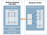
This package provides parallel processing on multiple cores/machines.
This package provides parallel processing on multiple cores on a single machine or on multiple machines that have access to a common directory.If you have multiple function calls that are independent
Transforms map data into lat/lon coordinates for a polar stereographic map projection. NSIDC/SCAR
parallel (default is -70). Note that some NSIDC data use 70 and some use 71. LON_POSY is the meridian in degrees along the positive Y axis of the map (default is 0) Equations from: Map
polarPcolor draws a pseudocolor plot in polar coordinates with a polar grid.
Transforms lat/lon data into map coordinates for a polar stereographic map projection. NSIDC/SCAR
(default is 6378137.0 m, WGS84) ECCENTRICITY is the earth's misshapenness (default is 0.08181919) LAT_TRUE is the latitude of true scale in degrees, aka standard parallel (default is -70). Note

Calculates CIExy coordinate of a light source using photo luminescence data and predict color.
Convert values given by a contour matrix to easy-to-use cells.

Utilities for manipulating GPS position data
A collection of utilities for translating GPS coordinates to related coordinate systems (Earth Centere Fixed, Topocentric, UTM) with auxiliary routins for horizon computation and ray ellipsoid

This app helps to understand and visualise three dimensional cylindrical coordinate system.
In a three-dimensional space a point can be located as the intersection of three orthogonal surfaces..This app help to understand cylindrical coordinate system. Unit vectors and differential lengths
Serial to Parallel Converter & vice-versa
It contains two function -1.ser2par : Converts Serial Data to Parallel Data2.par2ser : Converts Parllel data to Serial Data
The software solves the power flow problem in rectangular coordinates

This Function calculate the divergence of 3D symbolic vector field
This Function calculates the divergence of the 3D symbolic vector in Cartesian, Cylindrical, and Spherical coordinate system.function Div = divergence_sym(V,X,coordinate_system)V is the 3D symbolic
The use of parallel robots and their working and design
The matlab design for parallel robots
fast with one for loop series to parallel
fast with one for loop series to parallel
Tutorials: Parallel and GPU Computing with MATLAB: All in one (9 parts)
Version 1.5.0.1
MathWorks Parallel Computing Toolbox TeamTutorials on Parallel and GPU Computing with MATLAB
This submission contains all code examples used in tutorial series for Parallel and GPU Computing with MATLAB available here: http://www.mathworks.com/products/parallel
Interactive MATLAB script that can be used to perform time and coordinate calculations.
PDF document and interactive MATLAB script called csystems.m which can be used to perform a variety of time and coordinate calculations. This script performs the following types of time

These files are for 3-RRR Planar Parallel Manipulator Dexterity Index (DI), Manipulability Index (MI), workspace and so on...
are going to use these file, please cite this paper: " Modeling and Performance Analysis of Planar Parallel Manipulators "Feel free to contact me for more details.
Entry for Simulink Challenge 2020. Includes a Simulink Model which runs a self-driving car with a single front camera in Unreal Engine.
The function performs both reverse and direct problem-solving based on dual quaternions between two Cartesian coordinate systems (3D and 2D)
and direct problem-solving based on dual quaternions between two 3D Cartesian coordinate system% The function can also 2D transformation between given coordinate systems.% INPUT:% n :number of control

Like dsxy2figxy or ds2nfu, also work for 3D axes. An utility function to help annotation.

GUI allows you convert spherical coordinates to UTM coordinates
The source code of the parallel computing TEDA clustering algorithm
The package contains:1. ParallelTEDAClustering.m - The source code of the parallel computing TEDA clustering algorithm;2. demo.m - The demoReference: Gu X., Angelov P.P., Gutierrez G., Iglesias J.A
Inverters in parallel
parallel they don't operate.The two first files are two inverters individually connected to main grid, and the third is whole grid with two inverters and main grid. there is also an image of grid.Can any one

Parallel operation of a SM with an Infinite Bus
Parallel operation of a SM with an Infinite Bus
Performances of parallel MATLAB computations by splitted physical processors.
In this paper I describe some results on the use of virtual processors technology for parallelize some SPMD computational programs. The tested technology is the INTEL Hyper Threading on real
SimBiology model and code to perform CI and NCA analyses, and optimization using parallel computing.
parameters (SimBiology function: sbionca) * Illustrate justifications for using parallel computing such as dealing with out-of-memory simulations and increasing performance by introducing MATLAB functions and

Example complementing the blog post series “Unifying MATLAB and Simulink: A User Story Part” on the blog “Guy on Simulink”

Useful functions for geometry processing, constrainted optimization and image processing.
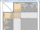
Starting from a given directory, the dependencies of all files are analyzed and visualized as a map.
dependencies and the folder structure is generated.Above screenshot and the example report is based on the "Parallel Coordinate Plots GUI toolbox" by Barnaby

This function can be used to create various plots of Lab color coordinates.

Shipment and reception of data through parallel port.
Shipment and reception of data through parallel port.For more information, visit: http://www.matpic.com

A toolbox for the design of complex machine learning experiments
takes charge of loading data, partitioning it, testing the algorithms and visualizing the results. Additionally, it has support for parallelizing the experiments, and enabling GPU support. This makes
Transform cartesian to curvilinear orthogonal coordinates, e.g. a flow-oriented coordinate system.
Converter form parallel to serial
This program is simple and fast that is used to convert from parallel to serialyou can use it as a functionparallel2series(information);
Linearly-constrained L1 minimization for compressed sensing
minimization problem min_u ||u||_1 + lambda ||A*u - f||_2^2Algorithms are based on greedy coordinate descent and the Bregman iterative method.
Computes curvature and curvature derivative tensors in each vertex of a triangle meshes

Simulation of autonomous connected vehicles for driving policy design in Mcity.

Converter Geodetic coordinates to Cartesian coordinates on Triaxial,Biaxial ellipsoide or Sphere

3D Space Coordinate Transformations
# 3d-coordinate-transformations3D Space Coordinate Transformations for Robotics Applications[
Fast Adaptive Coordinate Descent for Large- scale (D>>100) Non-linear Optimization
Fast Adaptive Coordinate DescentThe algorithm adapts an appropriate coordinate system using PCA and performs a coordinate descent along principal components.For simple demo on 2-dimensional
This Function calculate the gradient of 3D scalar function
This Function calculates the gradient of 3D scalar function in Cartesian, Cylindrical, and Spherical coordinate system. function gradientSym = gradient _sym(V,X,coordinate_system) V is the 3D scalar

This Function calculate the curl of 3D symbolic vector field
This Function calculates the curl of the 3D symbolic vector in Cartesian, Cylindrical, and Spherical coordinate system. function CurlSym = curl_sym(V,X,coordinate_system)V is the 3D symbolic vector

Geometric computing library for 3D shapes: meshes, points, lines, planes...

A demonstration on how to synchronize multiple xPC Targets using the parallel port.
Multiple targets can be synchronized using the parallel port available on most PC’s. Designating one model as the master to generate an interrupt source on the parallel port, single or multiple

Model of a parallel-series hybrid-electric vehicle with system-level and detailed variants of electrical system.
files compatible with earlier releases of MATLAB.For R2025b: Use Download button above For R2025a: https://github.com/mathworks/Simscape-HEV-Series-Parallel/archive/25.1.5.0.zipFor R2024b

This function returns normalized coordinates in plot, semilogx, semilogy and loglog plots.
Inspired by http://www.mathworks.com/matlabcentral/fileexchange/10656-data-space-to-figure-units-conversion, which featured coordinate normalization in regular plots, I wrote this quick function to

Cartesian to Curvilinear coordinate forward and backward transformation
Version 1.0.0.0
Bart VermeulenTransform 2D cartesian coordinates to channel fitted curvilinear coordinates and backward
[Si,Ni]=XY2SN(Xc,Yc,Xi,Yi) Converts the Cartesian coordinates Xi and Yi to the channel fitted coordinate Si and Ni using the centreline defined through the Cartesian coordinates of its vertices Xc and Yc
Use MATLAB/Simulink to accelerate testing data analysis and vehicle control algorithm simulation.
Convert form XYZ coordinate to YBC format (LRA).
XYZ2YBC convert form XYZ coordinate to YBC format (LRA)XYZ2YBC(X,Y,Z) convert the X,Y,Z values to Y,B,C values. assuming the bend radius is zero. the size of X,Y and Z must be the
The Rparallel3 m-file function computes the total resistance of n resistors in parallel.
This m-file function can be used in any area where the total electrical resistance of parallel resistors is required.Example usage:>> z = Rparallel3(1,1,1)z = 0.3333>> By using

Various plotting/drawing functions that can be saved as KML output, and loaded in Google Earth
Simplifies managing resources such as large data within PARFOR loops and SPMD blocks
Note that since MATLAB release R2015b, parallel.pool.Constant supersedesthe WorkerObjWrapper. The WorkerObjWrapper is designed for situations where a piece ofdata is needed multiple times inside the
Input black & white image is converted into segments.
This function segment_parallel segments the input black & white image to segmented image. The segments are numbered as and when new segments comes up. The input image should have only 1s and

Programs using curvilinear coordinates, and tensor concepts are given.
) runcoord plots intersecting coordinate surfaces for several typical coordinate systems 2) runmetric computes and prints metric tensor properties for a general curvilinear coordinate system specified in a
You can also select a web site from the following list
Americas
- América Latina (Español)
- Canada (English)
- United States (English)
Europe
- Belgium (English)
- Denmark (English)
- Deutschland (Deutsch)
- España (Español)
- Finland (English)
- France (Français)
- Ireland (English)
- Italia (Italiano)
- Luxembourg (English)
- Netherlands (English)
- Norway (English)
- Österreich (Deutsch)
- Portugal (English)
- Sweden (English)
- Switzerland
- United Kingdom (English)
Asia Pacific
- Australia (English)
- India (English)
- New Zealand (English)
- 中国
- 日本Japanese (日本語)
- 한국Korean (한국어)