Satellite Mission Analysis
satelliteScenario
object; use functions to support Aerospace Blockset™ spacecraftGenerate satellite scenarios to model and visualize satellites in orbit and perform
additional analyses, such as computing access with ground stations. You can directly
call satelliteScenario and satelliteScenarioViewer
objects. To create objects for other classes, use their object creation functions (for
example, satellite
for a Satellite object and groundStation for a GroundStation object).
Objects
Functions
Topics
- Satellite Scenario Key Concepts
Learn common satellite scenario visualization terms.
- Spacecraft Key Concepts
Define coordinate systems for navigation when modeling with the Aerospace Toolbox software.
- Propagation Methods in Spacecraft Simulation
This section outlines analytical and numerical methods you use to propagate a spacecraft orbit and configure end‑to‑end simulation workflows in the Aerospace Toolbox.
- Optimize a Satellite Constellation While Satisfying Constraints on Ground Station Access
Find minimum-cost satellite constellation able to meet coverage requirements.
- Satellite Scenario Basics
Build complete satellite scenario simulation.
- Model, Visualize, and Analyze Satellite Scenario
Model satellites in orbit, analyze access between the satellites and the ground stations, and visualize the fields of view and ground tracks of the satellites.
- Orbit Propagation Methods
Analyze the motion and dynamics of aerospace vehicles with short-period requirements, boundary line, and altitude contour plots.
Featured Examples
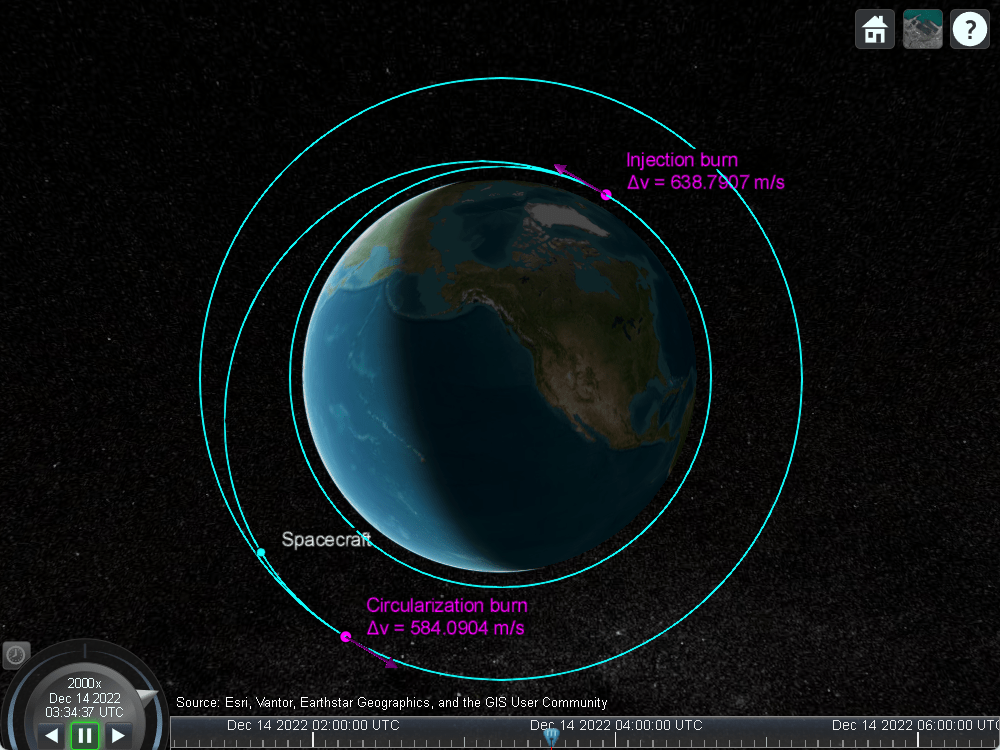
Simulate Hohmann Transfer in Satellite Scenario using Impulsive Maneuvers
Simulate Hohmann Transfer using Impulsive Maneuvers.

Modeling Satellite Constellations Using Ephemeris Data
Add time-stamped ephemeris data for a constellation of 24 satellites to a satellite scenario for access analysis.
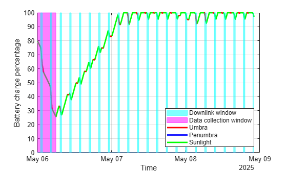
Estimate Satellite Battery Charge State Using Satellite Scenario and Eclipse Analysis
Model and plot your satellite’s battery charge state over time using eclipse and access analysis during data collection and downlink operations.

Comparison of Orbit Propagators
Compare the orbits predicted by the Two-Body-Keplerian, Simplified General Perturbations-4 (SGP4) and Simplified Deep-Space Perturbations-4 (SDP4) orbit propagators.

Satellite Constellation Access to Ground Station
Set up access analysis between a ground station and conical sensors onboard a constellation of satellites.

Detect and Track LEO Satellite Constellation with Ground Radars
Import a Two-Line Element (TLE) file of a satellite constellation, simulate radar detections of the constellation, and track the constellation.

Multi-Hop Path Selection Through Large Satellite Constellation
Determine the path through a large constellation.

Modeling Custom Satellite Attitude and Gimbal Steering
Point satellite or gimbal in satellite scenario using logged orientation data from
timetable or timeseries.

Analyze Access Between a Satellite Constellation and an Aircraft
Model an aircraft trajectory and a Walker-Delta satellite constellation using Aerospace Toolbox, and analyze and visualize the computed access between the aircraft and satellite constellation.

Satellite Conjunction Finder
Find potential events of close proximity or conjunctions of two satellites.

Model a Lunar Free-Return Trajectory in Satellite Scenario Using Numerical Orbit Propagation
Simulate a lunar free return trajectory using satellite scenario.