addMesh
Add new static mesh to UAV scenario
Description
addMesh(___, specifies
        additional options using name-value arguments.Name=Value)
Examples
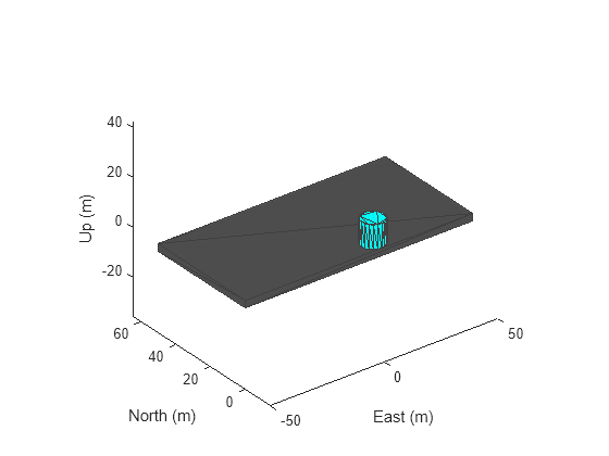
Create a UAV Scenario.
scene = uavScenario("UpdateRate",100,"StopTime",1);
Add the ground and a building as meshes.
addMesh(scene,"Polygon", {[-50 0; 50 0; 50 50; -50 50], [-3 0]}, [0.3 0.3 0.3]); addMesh(scene,"Cylinder", {[10 5 5], [0 10]}, [0 1 1]);
Visualize the scenario.
show3D(scene);

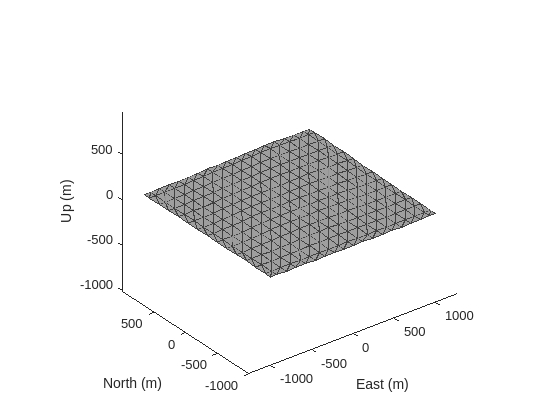
Create a UAV scenario centered on New York City, and add a terrain mesh based on the Global Multi-Resolution Terrain Elevation Data (GMTED2010) data set.
scene = uavScenario(ReferenceLocation=[40.707088 -74.012146 0]); xlimits = [-1000 1000]; ylimits = [-1000 1000]; color = [0.6 0.6 0.6]; terrainInfo = addMesh(scene,"terrain",{"gmted2010",xlimits,ylimits},color,Verbose=true)
terrainInfo = struct with fields:
       TerrainName: "gmted2010"
     LatitudeRange: [-90 90]
    LongitudeRange: [-180 180]
show3D(scene);

Add buildings by importing them from an OSM file that contains the buildings of Manhattan, manhattan.osm.[1]
xlimits = [-800 800]; ylimits = [-800 800]; color = [0 1 0]; osmInfo = addMesh(scene,"buildings",{"manhattan.osm",xlimits,ylimits,"auto"},color,Verbose=true)
osmInfo = struct with fields:
             OSMFileName: "/mathworks/devel/sbs/25/rprasad.Bdoc23a.j2033780.Aug12/matlab/toolbox/shared/openstreetmapdata/manhattan.osm"
           LatitudeRange: [40.7010 40.7182]
          LongitudeRange: [-74.0188 -74.0003]
       TotalNumBuildings: 836
    NumImportedBuildings: 657
show3D(scene);

[1] The file was downloaded from https://www.openstreetmap.org, which provides access to crowd-sourced map data all over the world. The data is licensed under the Open Data Commons Open Database License (ODbL), https://opendatacommons.org/licenses/odbl/.
Create a default UAV scenario.
scene = uavScenario;
Create a triangulation object from STL file.
stltri = stlread("multirotor.stl");Add a static mesh to the scenario, using the triangulation object as the input.
addMesh(scene,"custom",{stltri.Points stltri.ConnectivityList},[0.6350 0.0780 0.1840])Show the scene.
ax = show3D(scene); p = findobj(ax,"type","patch"); p.LineStyle = "none";

Input Arguments
UAV scenario, specified as a uavScenario object.
Mesh type, specified as "cylinder", "surface",
              "terrain", "polygon",
              "buildings", "unreal scene", or
              "custom". Specify the geometric parameters of the mesh using the
              geometry input.
Data Types: string | char
Mesh geometry, specified as a cell array of geometry parameters. Depending on the
              type input, the geometry parameters have different
              forms:
type Input Argument | Geometry Parameters | Description | 
|---|---|---|
"cylinder" | {[centerx centery radius],[zmin zmax]} | centerx and centery are the x- and
                      y-coordinates of the center of the cylinder, respectively.
                        radius is the radius of the cylinder in meters.
                        zmin and zmax are the minimum and
                      maximum z-axis coordinates of the cylinder in meters, respectively.  | 
"surface" | {meshGridX,meshGridY,z} | meshGridX, meshGridY and
                        z are all 2-D matrices of the same size that define the
                        xyz-points of the surface mesh. | 
"terrain" | {terrainName,XLimits,YLimits} | You must first call the addCustomTerrain function to load the terrain data and specify a
                      terrain name. Specify the minimum and maximum xy-limits as
                      two separate two-element vectors in local coordinates, or latitude-longitude
                      coordinates if the 'UseLatLon' name-value pair is
                        true. The xy-coordinates must be
                      specified in the ENU reference frame. | 
"polygon" | {cornerPoints,[zmin zmax]} | zmin and zmax are the minimum and
                      maximum z-axis coordinates of the polygon in meters, respectively.
                        cornerPoints contains the corner points of the polygon,
                      specified as a N-by-2 matrix, where N is
                      the number of corner points. The first column contains the x-coordinates and
                      the second column contains the y-coordinates in meters. | 
"buildings" | {osmFile,xBound,yBound,altitude} | 
                      
  | 
"unreal scene" | {sceneName,[centerX centerY centerZ],sceneYaw} | 
                      
  | 
"custom" | {vertices,faces} | vertices is an n-by-3 matrix of
                      mesh points in local coordinates. faces is an
                        n-by-3 integer matrix of indexes indicating the
                      triangular faces of the mesh. | 
Mesh color, specified as a RGB triplet.
Example: [1 0 0]
Name-Value Arguments
Specify optional pairs of arguments as
      Name1=Value1,...,NameN=ValueN, where Name is
      the argument name and Value is the corresponding value.
      Name-value arguments must appear after other arguments, but the order of the
      pairs does not matter.
    
      Before R2021a, use commas to separate each name and value, and enclose 
      Name in quotes.
    
Example: addMesh(scene,"Cylinder",{[46 42 5],[0 20]},[0 1
          0],UseLatLon=true)
Enable latitude and longitude coordinates, specified as true or
                false. 
When specified as
true, the x, y, and z coordinates in thegeometryinput are interpreted as latitude, longitude, and altitude, respectively. Vertices for custom mesh use east-north-up (ENU) as the reference frame.When specified as
false, the x, y, and z coordinates in thegeometryinput are interpreted as Cartesian coordinates.
Reference frame of the geometry input, specified as an inertial frame name defined
              in the InertialFrames property of the uavScenario
              object scene. You can add new inertial frames to the scenario
              using the addInertialFrame object function.
The scenario only accepts frames that have z-axis rotation with
              respect to the  "ENU" frame.
For terrain, building, and Unreal scene import, the reference frame must be
                "ENU".
Verbose mode for OSM building or terrain file imports, specified as a logical
                true (1) or false
                (0). When you specify this argument as true,
                addMesh returns information about the file and import process.
              The information returned depends on the type of file.
If you specify an output argument, verbose mode returns the import information as
              a structure, info.
              Otherwise, verbose mode prints the import information in the Command Window.
Output Arguments
File import information, returned as a structure. The fields contained depend on the type of file:
| File Type | Fields | 
|---|---|
| OSM Building | 
                      
  | 
| Terrain | 
                      
  | 
To return this output argument, you must specify the Verbose
            name-value argument as true.
Tips
OSM files may load slowly when a high number of buildings are specified in the file. If you experience long load times, consider reducing the number of buildings to load more quickly.
Version History
Introduced in R2020bThe addMesh function now supports importing a Suburban scene or US City Block scene as a mesh into a UAV
        scenario by specifying the mesh geometry as "unreal scene".
See Also
uavScenario | addCustomTerrain | removeCustomTerrain | terrainHeight
MATLAB Command
You clicked a link that corresponds to this MATLAB command:
Run the command by entering it in the MATLAB Command Window. Web browsers do not support MATLAB commands.
Select a Web Site
Choose a web site to get translated content where available and see local events and offers. Based on your location, we recommend that you select: .
You can also select a web site from the following list
How to Get Best Site Performance
Select the China site (in Chinese or English) for best site performance. Other MathWorks country sites are not optimized for visits from your location.
Americas
- América Latina (Español)
 - Canada (English)
 - United States (English)
 
Europe
- Belgium (English)
 - Denmark (English)
 - Deutschland (Deutsch)
 - España (Español)
 - Finland (English)
 - France (Français)
 - Ireland (English)
 - Italia (Italiano)
 - Luxembourg (English)
 
- Netherlands (English)
 - Norway (English)
 - Österreich (Deutsch)
 - Portugal (English)
 - Sweden (English)
 - Switzerland
 - United Kingdom (English)