addCustomTerrain
Add custom terrain data
Description
addCustomTerrain(
adds terrain data specified by terrainName,files)files for use with UAV
scenarios. Add the terrain to uavScenario objects using the addMesh
object function. Custom terrain data is available for current and future sessions of
MATLAB® until you call removeCustomTerrain.
addCustomTerrain(___,
adds custom terrain data with additional options specified by one or more name-value
pairs.Name,Value)
Examples
This example shows how to add and remove custom terrain data from a UAV scenario.
Add Custom Terrain Data
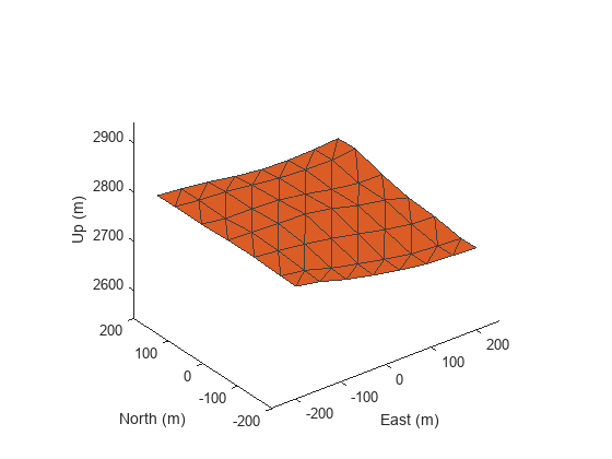
Add terrain for a region in Boulder, CO. The DTED file was downloaded from the "SRTM Void Filled" data set available from the U.S. Geological Survey.
dtedfile = "n39_w106_3arc_v2.dt1";
addCustomTerrain("CustomTerrainBoulder",dtedfile)
Create a UAV scenario with the origin set at Boulder, CO. Then, add a terrain mesh.
scenario = uavScenario(ReferenceLocation=[39.5 -105.5 0]);
addMesh(scenario,"terrain",{"CustomTerrainBoulder",[-200 200],[-200 200]},[0.8500 0.3250 0.0980])
Show the scenario.
show3D(scenario);
Remove Custom Terrain Data
Use removeCustomTerrain to remove the custom terrain data.
removeCustomTerrain("CustomTerrainBoulder")Input Arguments
Name-Value Arguments
Tips
You can find and download DTED files by using EarthExplorer, a data portal provided by the US Geological Survey (USGS). From the list of data sets, search for DTED files by selecting Digital Elevation, SRTM, and then SRTM 1 Arc-Second Global and SRTM Void Filled.
Version History
Introduced in R2021a