Project and Display Raster Data
To project or unproject regularly-spaced raster data that is associated with a geographic
or map reference object, you must first create a coordinate grid that matches the size of the
raster. Use different grid creation functions depending on which way you are projecting. When
you project latitude-longitude coordinates to x-y
coordinates, create a grid using the geographicGrid
function. When you unproject x-y coordinates to
latitude-longitude coordinates, create a grid using the worldGrid
function.
After transforming the raster data, you can display it on a map using visualization
functions such as mapshow and geoshow. Use mapshow for projected x-y coordinates
and geoshow for unprojected latitude-longitude coordinates.
Project Raster Data
To project data that is associated with a geographic raster reference object, first create a grid of latitude-longitude coordinates for each point in the raster. Then, project the geographic coordinates to x-y map coordinates.
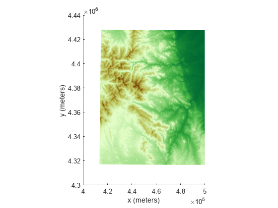
For example, import elevation raster data as an array and a geographic cells reference object. Get the latitude-longitude coordinates for each point in the raster by using the geographicGrid function.
[Z,R] = readgeoraster('n39_w106_3arc_v2.dt1');
[lat,lon] = geographicGrid(R);
Now that you have your grid, select a map projection to use when projecting the coordinates. For this example, create a projcrs object for UTM zone 13 in the northern hemisphere. Then, project the latitude-longitude coordinates to x-y coordinates.
p = projcrs(32613);
[x,y] = projfwd(p,lat,lon);
Display the projected raster as a surface by calling mapshow and specifying the x-y coordinates and elevation array. Add axis labels and apply a colormap appropriate for elevation data.
figure
mapshow(x,y,Z,'DisplayType','surface')
xlabel('x (meters)')
ylabel('y (meters)')
demcmap(Z)
If the geographic CRS of the latitude-longitude coordinates does not match the geographic CRS of the projected CRS, then the projected coordinates may be inaccurate. You can find the geographic CRS of a projcrs object or a geographic raster reference object by querying their GeographicCRS properties.
p.GeographicCRS.Name
ans =
"WGS 84"
R.GeographicCRS.Name
ans =
"WGS 84"
The DTED file used in this example is courtesy of the US Geological Survey.
Unproject Raster Data
To unproject data that is associated with a map raster reference object, first create a grid of x-y coordinates for each point in the raster. Then, unproject the x-y map coordinates to geographic coordinates.
For example, import an image of Boston as an array and a map cells reference object. Get information about the map projection as a projcrs object by querying the ProjectedCRS property of the reference object.
[Z,R] = readgeoraster('boston.tif');
p = R.ProjectedCRS;
Get the x-y coordinates for each point in the raster by using the worldGrid function.
[x,y] = worldGrid(R);
Unproject the x-y coordinates to latitude-longitude coordinates by using the projinv function and specifying the projcrs object and coordinate grid.
[lat,lon] = projinv(p,x,y);
Display the unprojected image by calling geoshow and specifying the latitude-longitude coordinates and image array. By default, geoshow displays coordinates using a Plate Carrée projection. Then, add axis labels.
figure
geoshow(lat,lon,Z)
xlabel('Longitude (degrees)')
ylabel('Latitude (degrees)')

See Also
Functions
projinv|projfwd|intrinsicToWorld|meshgrid|worldGrid