Main Content

surfacegamma

Gamma value for different terrains

Since R2021a

Description

G = surfacegamma(TerrainType) returns the γ value for the specified terrain. The γ value is for an operating frequency of 10 GHz.

G = surfacegamma(TerrainType,FREQ) specifies the operating frequency of the system.

example

surfacegamma displays several terrain types and their corresponding γ values. These γ values are for an operating frequency of 10 GHz.

Examples

collapse all

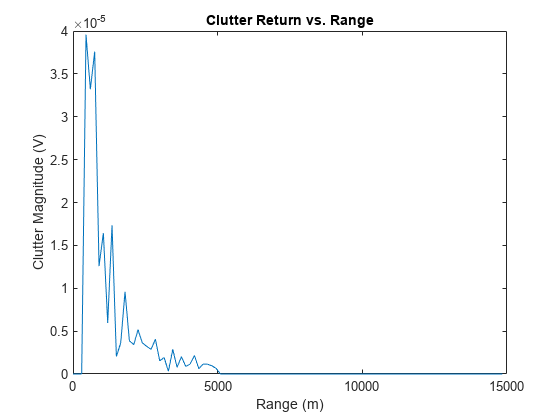
Determine the γ value for a wooded area, and then simulate the clutter return from that area. Assume the radar system uses a single cosine pattern antenna element and has an operating frequency of 300 MHz.

fc = 300e6;
g = surfacegamma('woods',fc);
clutter = constantGammaClutter('Gamma',g, ...
    'Sensor',phased.CosineAntennaElement, ...
    'OperatingFrequency',fc);
x = clutter();
r = (0:numel(x)-1)/(2*clutter.SampleRate) * ...
    clutter.PropagationSpeed;
plot(r,abs(x))
xlabel('Range (m)')
ylabel('Clutter Magnitude (V)')
title('Clutter Return vs. Range')

Figure contains an axes object. The axes object with title Clutter Return vs. Range, xlabel Range (m), ylabel Clutter Magnitude (V) contains an object of type line.

Input Arguments

collapse all

Terrain type, specified as one of these:

  • "Sea State 3"

  • "Sea State 5"

  • "Woods"

  • "Metropolitan"

  • "Rugged Mountain"

  • "Farmland"

  • "Wooded Hill"

  • "Flatland"

Data Types: char | string

Operating frequency of radar system in hertz, specified as a scalar or a vector.

Data Types: double

Output Arguments

collapse all

Gamma value, γ, in decibels, for constant-γ clutter model, returned as a scalar.

More About

collapse all

Gamma

A frequently used model for clutter simulation is the constant gamma model. This model uses a parameter, γ, to describe clutter characteristics of different types of terrain. Values of γ are derived from measurements.

Algorithms

The γ values for the terrain types "Sea State 3", "Sea State 5", "Woods", "Metropolitan", and "Rugged Mountain" are from [2]. The γ values for the terrain types "Farmland", "Wooded Hill", and "Flatland" are from [3].

Measurements provide values of γ for a system operating at 10 GHz. The γ value for a system operating at frequency f is:

γ=γ0+5log(ff0)

where γ0 is the value at frequency f0 = 10 GHz.

References

[1] Barton, David. "Land Clutter Models for Radar Design and Analysis," Proceedings of the IEEE. Vol. 73, Number 2, February, 1985, pp. 198–204.

[2] Long, Maurice W. Radar Reflectivity of Land and Sea, 3rd Ed. Boston: Artech House, 2001.

[3] Nathanson, Fred E., J. Patrick Reilly, and Marvin N. Cohen. Radar Design Principles, 2nd Ed. Mendham, NJ: SciTech Publishing, 1999.

Extended Capabilities

Version History

Introduced in R2021a