buffer
Description
buffered = buffer(shape,dist)dist. By default, the function outwardly buffers the shape.
Examples
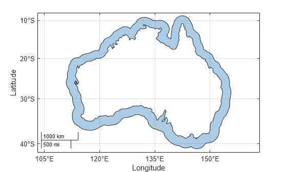
Read world land areas into the workspace as a geospatial table. The table represents the land areas using polygon shapes in geographic coordinates. Create a subtable that contains the table row for Australia. Then, extract the polygon shape for Australia.
land = readgeotable("landareas.shp");
australia = geocode("australia",land);
shape = australia.Shape;
For shapes in geographic coordinates, the buffer distance units must match the angle unit of the geographic coordinate reference system (CRS) associated with the shape. Find the angle unit. The result indicates that the buffer distance must be in degrees.
shape.GeographicCRS.AngleUnit
ans =
"degree"
Buffer the polygon shape by 2 degrees.
buffered = buffer(shape,2);
Create a map that displays the buffered shape and the outline of the original polygon.
figure
geobasemap none
geoplot(buffered)
hold on
geoplot(shape,LineWidth=2,FaceColor="none")
Read road data for an area in Concord, MA as a geospatial table. The table represents the roads using line shapes in planar coordinates. Create a subtable containing the line shapes for two named roads. Then, extract the line shapes.
roads = readgeotable("concord_roads.shp");

names = ["SOUTHFIELD CIRCLE","RIVERDALE ROAD"];
subroads = geocode(names,roads);

shape = subroads.Shape
shape=4×1 maplineshape array with properties:
                NumParts: [4×1 double]
                Geometry: "line"
    CoordinateSystemType: "planar"
            ProjectedCRS: [1×1 projcrs]
For shapes in planar coordinates, the buffer distance units must match the length unit of the projected CRS associated with the shape. Find the length unit. The result indicates that the buffer distance must be in meters.
shape.ProjectedCRS.LengthUnit
ans =
"meter"
Buffer the line shapes by 15 meters.
buffered = buffer(shape,15);
Create a map that displays the buffered shapes and the original lines. The overlapping buffered shapes indicate that the road consists of multiple line shapes.
figure
geoplot(buffered)
hold on
geoplot(shape,LineWidth=2)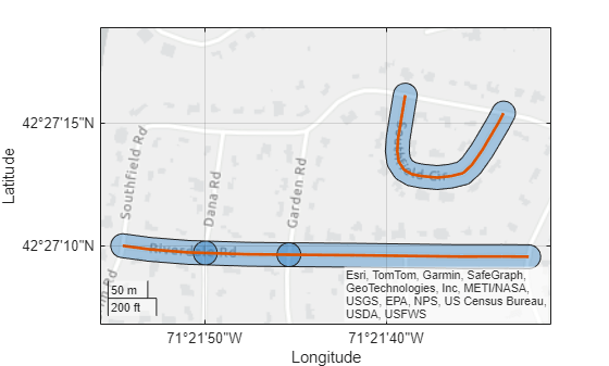
Read a shapefile containing the coordinates of locations in Boston as a geospatial table. The table represents the locations using point shapes in planar coordinates. Extract the point shapes.
places = readgeotable("boston_placenames.shp");
shape = places.Shape
shape =
13×1 mappointshape array with properties:
NumPoints: [13×1 double]
X: [13×1 double]
Y: [13×1 double]
Geometry: "point"
CoordinateSystemType: "planar"
ProjectedCRS: [1×1 projcrs]
Find the length unit to use for the buffer distances. The result indicates that the buffer distances must be in meters.
shape.ProjectedCRS.LengthUnit
ans =
"meter"
For each shape, specify a random buffer distance between 100 meters and 400 meters. Then, buffer the point shapes.
sz = size(shape);
dist = 100 + (400-100)*rand(sz);
buffered = buffer(shape,dist);
Create a map that displays the buffered shapes and the original point shapes.
figure
geoplot(buffered)
hold on
geoplot(shape)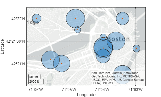
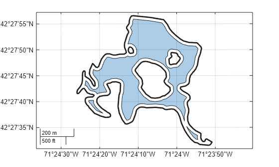
Read a shapefile containing hydrographic data for Concord, MA as a geospatial table. The table represents the data using polygon shapes in planar coordinates. Create a subtable containing the polygon shape for a pond. Then, extract the polygon shapes.
hydro = readgeotable("concord_hydro_area.shp");
pond = hydro(14,:);
shape = pond.Shape
shape =
mappolyshape with properties:
NumRegions: 1
NumHoles: 3
Geometry: "polygon"
CoordinateSystemType: "planar"
ProjectedCRS: [1×1 projcrs]
Find the length unit to use for the buffer distance. The result indicates that the buffer distance must be in meters.
shape.ProjectedCRS.LengthUnit
ans =
"meter"
Inwardly buffer the polygon shape by 20 meters by specifying the Direction name-value argument.
buffered = buffer(shape,20,Direction="in");Create a map that uses the projected CRS associated with the shape. Then, display the buffered polygon and the outline of the original polygon.
figure
newmap(shape.ProjectedCRS)
geoplot(buffered)
hold on
geoplot(shape,LineWidth=2,FaceColor="none")
Since R2025a
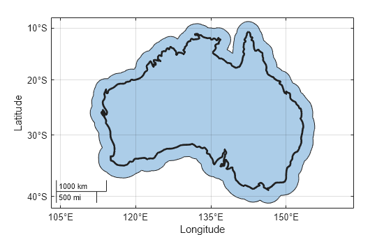
To outwardly buffer a polygon shape, buffer the shape by using the buffer function and then remove the original shape by using the subtract function.
Read world land areas into the workspace as a geospatial table. The table represents the land areas using polygon shapes in geographic coordinates. Create a subtable that contains the table row for Australia. Then, extract the polygon shape for Australia.
land = readgeotable("landareas.shp");
australia = geocode("australia",land);
shape = australia.Shape;
Buffer the polygon shape by 2 degrees.
buffered = buffer(shape,2);
Remove the original shape from the buffered shape by using the subtract function.
outbuffered = subtract(buffered,shape);
Create a map that displays the outwardly buffered shape.
figure
geobasemap none
geoplot(outbuffered)