loximuth
Loximuthal Projection
Classification
Pseudocylindrical
Identifier
loximuth
Graticule
Central Meridian: Straight line at least half as long as the Equator. Actual length depends on the choice of central latitude. Length is 0.5 when the central latitude is the Equator, for example, and 0.65 for central latitudes of 40º.
Other Meridians: Complex curves intersecting at the poles and concave toward the central meridian.
Parallels: Equally spaced straight parallel lines, perpendicular to the central meridian.
Poles: Points.
Symmetry: About the central meridian. Symmetry about the Equator only when it is the central latitude.
Features
This projection has the special property that from the central point (the intersection of the central latitude with the central meridian), rhumb lines (loxodromes) are shown as straight, true to scale, and correct in azimuth from the center. This differs from the Mercator projection, in that rhumb lines are here shown in true scale and that unlike the Mercator, this projection does not maintain true azimuth for all points along the rhumb lines. Scale is true along the central meridian and is constant along any parallel, but not, generally, between parallels. It is free of distortion only at the central point and can be severely distorted in places. However, this projection is designed for its specific special property, in which distortion is not a concern.
Parallels
For this projection, only one standard parallel is specified: the central latitude described above. Specification of this central latitude defines the center of the loximuthal projection. The default value is 0º.
Remarks
This projection was presented by Karl Siemon in 1935 and independently by Waldo R. Tobler in 1966. The Bordone Oval projection of 1520 was very similar to the Equator-centered loximuthal.
This implementation of the loximuthal projection is applicable only for coordinates that are referenced to a sphere. If you want to project coordinates that are referenced to an ellipsoid, using the
projfwdorprojinvfunctions, then create aprojcrsobject instead of a map projection structure. You can create aprojcrsobject for the loximuthal projection using the ESRI authority code 54023. For example:projcrs(54023,'Authority','ESRI').
Example
landareas = shaperead('landareas.shp','UseGeoCoords',true);
axesm ('loximuth', 'Frame', 'on', 'Grid', 'on');
geoshow(landareas,'FaceColor',[1 1 .5],'EdgeColor',[.6 .6 .6]);
tissot;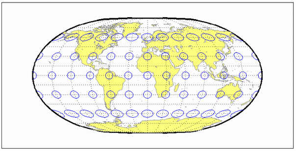
Version History
Introduced before R2006a