gnomonic
Gnomonic Projection
Classification
Azimuthal
Identifier
gnomonic
Graticule
The graticule described is for a polar aspect.
Meridians: Equally spaced straight lines intersecting at the central pole. The angles displayed are the true angles between meridians.
Parallels: Unequally spaced circles centered on the central pole. Spacing increases rapidly away from this pole. The Equator and the opposite hemisphere cannot be shown
Pole: The central pole is a point; the other pole is not shown.
Symmetry: About any meridian.
Features
This is a perspective projection from the center of the globe on a plane tangent at the center point, which is a pole in the common polar aspect, but can be any point. Less than one hemisphere can be shown with this projection, regardless of its center point. The significant property of this projection is that all great circles are straight lines. This is useful in navigation, as a great circle is the shortest path between two points on the globe. Only the center point enjoys true scale and zero distortion. This projection is neither conformal nor equal-area.
Parallels
There are no standard parallels for azimuthal projections.
Remarks
This projection may have been first developed by Thales around 580 B.C. Its name is derived from the gnomon, the face of a sundial, since the meridians radiate like hour markings. This projection is also known as a gnomic or central projection.
This implementation of the gnomonic projection is applicable only for coordinates that are referenced to a sphere.
Mapping Toolbox™ uses a different implementation of the gnomonic projection for displaying coordinates on
axesm-based maps than for projecting coordinates using theprojfwdorprojinvfunction. These implementations may produce differing results.
Limitations
Data greater than 65º distant from the center point is trimmed.
Example
landareas = shaperead('landareas.shp','UseGeoCoords',true);
axesm ('gnomonic', 'Frame', 'on', 'Grid', 'on');
geoshow(landareas,'FaceColor',[1 1 .5],'EdgeColor',[.6 .6 .6]);
tissot;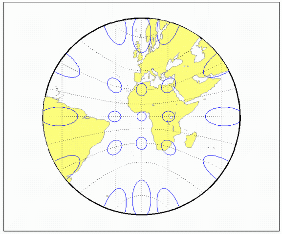
Version History
Introduced before R2006a