15 results

Geolocate data points from ocean color bin indices.

This project shows how to plot and create movies of global gridded space weather data using matlab.

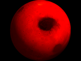
The NASA Calipso model is converted here to wavefront obj format and displayed using trisurf and materials.
Work with a medium-resolution dataset from MOLA.

NACA 4-Digit airfoil plotter.

Space view of globe with Delaunay mesh of equidistant points.

Acquire land surface temps from Berkeley Earth Surface Temperature study, NOAA, and NASA-Goddard.
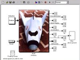
NASA HL-20 Lifting Body Airframe Modeled with Simulink and Aerospace Blockset.

UIElements is a Graphic User Interface (GUI) to select and analyze the species included in NASA's database and the Third Millenium database.

Demonstrates how to download NASA Earthshots data with RESTful get.

Allows easy retrieval of Ocean Pathfinder altimetry data.

Thermodynamic Fluid Properties

Returns UTIG ICECAP field seasons associated with input times.

A function set to create an animation of the gravitational wave deformation effect on space interferometer LISA.

Port from the NASA EngineSim source-code to Matlab
You can also select a web site from the following list
Americas
- América Latina (Español)
- Canada (English)
- United States (English)
Europe
- Belgium (English)
- Denmark (English)
- Deutschland (Deutsch)
- España (Español)
- Finland (English)
- France (Français)
- Ireland (English)
- Italia (Italiano)
- Luxembourg (English)
- Netherlands (English)
- Norway (English)
- Österreich (Deutsch)
- Portugal (English)
- Sweden (English)
- Switzerland
- United Kingdom(English)
Asia Pacific
- Australia (English)
- India (English)
- New Zealand (English)
- 中国
- 日本Japanese (日本語)
- 한국Korean (한국어)