Main Content
10 results

Useful tool for rendering and outputting information rich images

Solves the 1D Shallow Water Equations for a Dam Break scenario
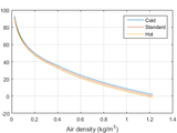
Finds altitude in the atmosphere as a function of air density.

Convert elevations between the WGS84 ellipsoid and the GL04c geoid.

Finds peaks, locations, fwhms and area in signal.

This function set figures' position to avoid overlap of figures.
This file contain child percentiles table of growth and very simple plot - user data can be added.

EXPORT_FIGURE is a simple and user-friendly program to assist people in exporting/saving figures based on journals' standards
tugas esprok
This function gets some wave heights
You can also select a web site from the following list
Americas
- América Latina (Español)
- Canada (English)
- United States (English)
Europe
- Belgium (English)
- Denmark (English)
- Deutschland (Deutsch)
- España (Español)
- Finland (English)
- France (Français)
- Ireland (English)
- Italia (Italiano)
- Luxembourg (English)
- Netherlands (English)
- Norway (English)
- Österreich (Deutsch)
- Portugal (English)
- Sweden (English)
- Switzerland
- United Kingdom(English)
Asia Pacific
- Australia (English)
- India (English)
- New Zealand (English)
- 中国
- 日本Japanese (日本語)
- 한국Korean (한국어)