Solar Eclipse 2024 and MATLAB R2024a
Are you going to be in the path of totality? How can you predict, track, and simulate the solar eclipse using MATLAB?
6 Comments
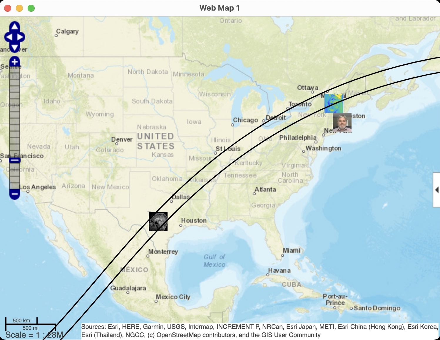
Time DescendingHere is the anticipated viewing location of another well-known MATLAB figure.
% Show where I'll be on the map
wmmarker(44.259444, -72.575833, ...
'OverlayName','Where''s Default Image Boy?', ...
'Description', 'Path of totality', ...
'icon', 'https://shorturl.at/ghsL1')
wmmarker(30.2752, -98.87198, ...
'OverlayName','Where''s Adam?', ...
'Description', 'Path of totality', ...
'icon', 'https://shorturl.at/vzA49')
wmmarker(42.15485, -71.35157, ...
'OverlayName','CJ at home', ...
'Description', 'off path', ...
'icon', 'https://shorturl.at/aoIZ6')
% Read in eclipse path data
eclipse = webread('https://eclipse.gsfc.nasa.gov/SEpath/SEpath2001/SE2024Apr08Tpath.html');
startChar = strfind(eclipse,'16:40');
endChar = strfind(eclipse,'ΔT =');
theTable = extractBetween(eclipse,startChar,(endChar));
pip = textscan(theTable{1,1},'%s %2s %5s %3s %5s %2s %5s %3s %5s %2s %5s %3s %5s %*[^\n]');
North = strcat(pip{1,2}," ",pip{1,3}," ",pip{1,4}," ",pip{1,5});
South = strcat(pip{1,6}," ",pip{1,7}," ",pip{1,8}," ",pip{1,9});
% Convert degrees-minutes strings to decimal
[northLat, northLon] = dmstr2degrees(North);
[southLat, southLon] = dmstr2degrees(South);
% Plot path of totality
wmline(northLat,northLon);
wmline(southLat,southLon)
wmlimits([25.311 44.892],[-106.08 -73.121])
function [lat, lon] = dmstr2degrees(str)
% Converts degrees-minutes in the form of "05 30.6S 149 47.6W" to latitude
% and longitude decimals
pattern = '(\d{2})\s+(\d{2}\.\d)([NS])\s+(\d{3})\s+(\d{2}\.\d)([EW])';
northTokens = regexp(str, pattern, 'tokens','once');
northTokens = vertcat(northTokens{:});
lat = dm2degrees(str2double(northTokens(:,1:2))) .* (strcmpi(northTokens(:,3),"N")*2-1);
lon = dm2degrees(str2double(northTokens(:,4:5))) .* (strcmpi(northTokens(:,6),"E")*2-1);
end
Here's where I'll be (run this in MATLAB)
% Show where I'll be on the map
wmmarker(30.2752, -98.87198, ...
'OverlayName','Where''s Adam?', ...
'Description', 'Path of totality', ...
'icon', 'https://shorturl.at/vzA49')
% Read in eclipse path data
% https://eclipse.gsfc.nasa.gov/SEpath/SEpath2001/SE2024Apr08Tpath.html
T = readtable("eclipsePathData.txt",'Delimiter',' ','TextType','string');
% Convert degrees-minutes strings to decimal
[northLat, northLon] = dmstr2degrees(T.NorthLatLon);
[southLat, southLon] = dmstr2degrees(T.SouthLatLon);
% Plot path of totality
wmline(northLat,northLon);
wmline(southLat,southLon)
wmlimits([25.311 44.892],[-106.08 -73.121])
function [lat, lon] = dmstr2degrees(str)
% Converts degrees-minutes in the form of "05 30.6S 149 47.6W" to latitude
% and longitude decimals
pattern = '(\d{2})\s+(\d{2}\.\d)([NS])\s+(\d{3})\s+(\d{2}\.\d)([EW])';
northTokens = regexp(str, pattern, 'tokens','once');
northTokens = vertcat(northTokens{:});
lat = dm2degrees(str2double(northTokens(:,1:2))) .* (strcmpi(northTokens(:,3),"N")*2-1);
lon = dm2degrees(str2double(northTokens(:,4:5))) .* (strcmpi(northTokens(:,6),"E")*2-1);
end

If you wanna read the file automatically, here is a hack with me added in too.
% Show where I'll be on the map
wmmarker(30.2752, -98.87198, ...
'OverlayName','Where''s Adam?', ...
'Description', 'Path of totality', ...
'icon', 'https://shorturl.at/vzA49')
wmmarker(42.15485, -71.35157, ...
'OverlayName','CJ at home', ...
'Description', 'off path', ...
'icon', 'https://shorturl.at/aoIZ6')
% Read in eclipse path data
eclipse = webread('https://eclipse.gsfc.nasa.gov/SEpath/SEpath2001/SE2024Apr08Tpath.html');
startChar = strfind(eclipse,'16:40');
endChar = strfind(eclipse,'ΔT =');
theTable = extractBetween(eclipse,startChar,(endChar));
pip = textscan(theTable{1,1},'%s %2s %5s %3s %5s %2s %5s %3s %5s %2s %5s %3s %5s %*[^\n]');
North = strcat(pip{1,2}," ",pip{1,3}," ",pip{1,4}," ",pip{1,5});
South = strcat(pip{1,6}," ",pip{1,7}," ",pip{1,8}," ",pip{1,9});
% Convert degrees-minutes strings to decimal
[northLat, northLon] = dmstr2degrees(North);
[southLat, southLon] = dmstr2degrees(South);
% Plot path of totality
wmline(northLat,northLon);
wmline(southLat,southLon)
wmlimits([25.311 44.892],[-106.08 -73.121])
function [lat, lon] = dmstr2degrees(str)
% Converts degrees-minutes in the form of "05 30.6S 149 47.6W" to latitude
% and longitude decimals
pattern = '(\d{2})\s+(\d{2}\.\d)([NS])\s+(\d{3})\s+(\d{2}\.\d)([EW])';
northTokens = regexp(str, pattern, 'tokens','once');
northTokens = vertcat(northTokens{:});
lat = dm2degrees(str2double(northTokens(:,1:2))) .* (strcmpi(northTokens(:,3),"N")*2-1);
lon = dm2degrees(str2double(northTokens(:,4:5))) .* (strcmpi(northTokens(:,6),"E")*2-1);
end
Is it possible to get your co-ordinates from Google Maps or something into this? Maybe make a button that says 'Use my current location' that includes the API call? How would you do that?
Sign in to participate